A) A
B) B
C) C
D) D
Correct Answer

verified
Correct Answer
verified
Multiple Choice
What happens to a river as it flows through a delta and encounters the sea? 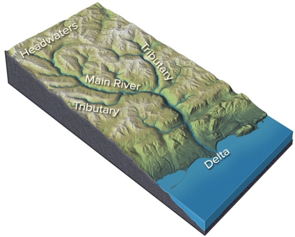
A) The discharge and water velocity increase.
B) The maximum sediment grain size carried by the river increases.
C) The total sediment load carried by the river decreases.
D) All of these are correct.
Correct Answer

verified
Correct Answer
verified
Multiple Choice
Which of the lettered sites would most likely be undercut by migration of a meander? 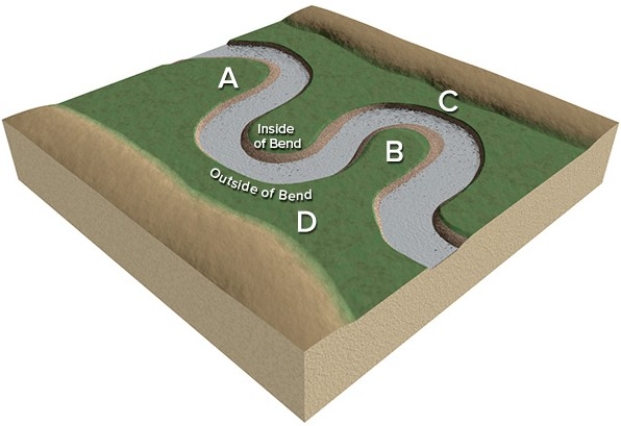
A) A
B) B
C) C
D) D
Correct Answer

verified
Correct Answer
verified
Multiple Choice
What type of stream is shown in this figure? 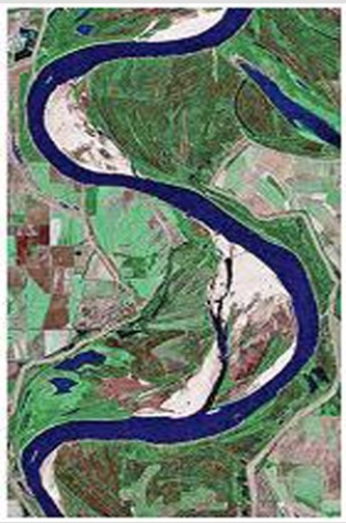
A) Braided stream
B) A stream whose channel has a low sinuosity
C) Meandering stream
D) A stream that lacks point bars
E) All of these are correct.
Correct Answer

verified
Correct Answer
verified
Multiple Choice
What is a reasonable interpretation for the flow event recorded by this hydrograph? 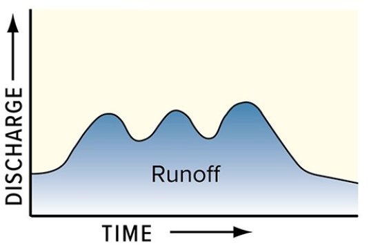
A) There were two pulses of runoff because there were two storms.
B) The drainage basin has several distinct parts.
C) One pulse could be due to snowmelt and the other to rain.
D) All of these are correct.
Correct Answer

verified
Correct Answer
verified
Multiple Choice
This figure shows four numbered river terraces,with 1 being the highest and 4 being the lowest.Which is the oldest terrace? 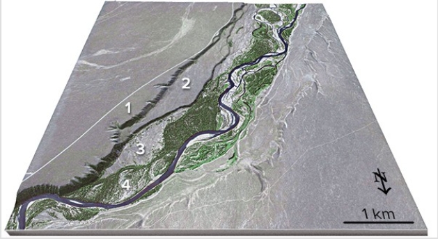
A) 1
B) 2
C) 3
D) 4
Correct Answer

verified
Correct Answer
verified
Multiple Choice
What is the mostly likely setting for this drainage pattern? 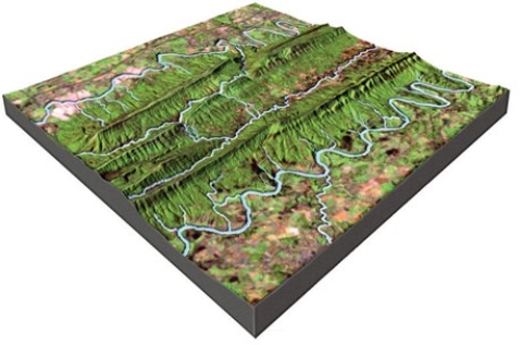
A) The rocks have a relatively equal resistance to erosion.
B) Drainages have followed a series of fractures that branch off of one another.
C) The area has folded or faulted rocks with different resistances to erosion.
D) A volcano once existed here but has been partly eroded away.
Correct Answer

verified
Correct Answer
verified
Multiple Choice
Which of the following is true of a 100-year flood?
A) A 100-year flood occurs every 100 years on a given stream.
B) The probability of a 100-year flood occurring on any given year is 1:100.
C) A 100-year flood cannot occur twice within 10 years.
D) The probability of a 100-year flood is related to how recently the last 100-year flood occurred.
Correct Answer

verified
Correct Answer
verified
Multiple Choice
Which of the following is not true about rivers?
A) Major rivers,like the upper Mississippi near the Great Lakes,must be relatively old rivers.
B) The boundary between hard rocks and soft rocks can be marked by waterfalls.
C) Loading and unloading of the crust by ice sheets can change the direction that rivers flow.
D) Different parts of a river can be different ages.
Correct Answer

verified
Correct Answer
verified
Multiple Choice
In this diagram,water velocity downstream generally 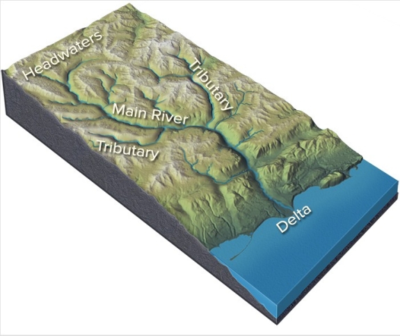
A) decreases.
B) remains the same.
C) increases.
D) There is no way to tell because discharge cannot be determined.
Correct Answer

verified
Correct Answer
verified
Multiple Choice
Which particles of sediment are most likely to be transported as suspended load?
A) Small,low density particles
B) Pebbles of average density
C) Sand and gravel of relatively high density
D) Dissolved ions in solution
E) All of these are correct.
Correct Answer

verified
Correct Answer
verified
Multiple Choice
What is the mostly likely setting for this drainage pattern? 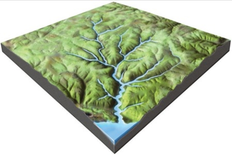
A) The rocks have a relatively equal resistance to erosion.
B) Drainages have followed a series of fractures that branch off of one another.
C) The area has folded or faulted rocks with different resistances to erosion.
D) A volcano once existed here but has been partly eroded away.
Correct Answer

verified
Correct Answer
verified
Multiple Choice
Formation of entrenched meanders can result from a
A) low-gradient river followed by downcutting.
B) braided river that later exceeds its capacity to carry sediment.
C) braided river followed by regional uplift.
D) steep-gradient mountain stream following by an increase in precipitation.
Correct Answer

verified
Correct Answer
verified
Multiple Choice
At what two stream profiles would overall stream velocity be greatest at the center of the profile? 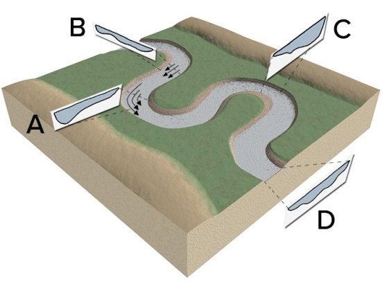
A) A and C
B) B and D
C) C and D
D) D and A
Correct Answer

verified
Correct Answer
verified
Multiple Choice
If a stream-cut canyon is deep and narrow,which of the following is most likely to be true?
A) Rocks in the canyon walls are relatively hard and easy to erode.
B) The stream is probably close to its base level.
C) Downcutting is occurring faster than widening.
D) The stream contains mostly small clasts,such as silt.
Correct Answer

verified
Correct Answer
verified
Multiple Choice
Bedrock and sediment in a stream is most susceptible to erosion if it is
A) in slow-moving water in an eddy.
B) in a site that is sheltered from oncoming clasts.
C) located in a turbulent part of the river.
D) composed entirely of large clasts that affect stream flow.
E) All of these are correct.
Correct Answer

verified
Correct Answer
verified
Multiple Choice
Which of the following is a condition favoring deposition of sediment?
A) An increase in water velocity
B) A decrease in gradient of the stream
C) An increase in turbulence of the water
D) An increase in the salt content of the water
E) A decrease in grain size as a clast breaks into two pieces
Correct Answer

verified
Correct Answer
verified
Multiple Choice
Which of the following does not influence whether sediment is picked up by a stream?
A) Size and density of the sediment
B) Turbulence of the moving water
C) Location of the sediment in the stream
D) Whether the stream flows north-south or east-west
Correct Answer

verified
Correct Answer
verified
Multiple Choice
Which of the following is not a common site for deposition of sediment?
A) Point bar
B) Distributary system
C) Levee
D) Cut bank
E) Floodplain
Correct Answer

verified
Correct Answer
verified
Multiple Choice
Which of the following is true about the base level of a stream?
A) Base level indicates the normal (or base) flow level before flooding.
B) The flat top of a mountain is the ultimate base level for most streams.
C) A mountain is close to its base level if bedrock is close to the surface.
D) Most streams have lower gradient close to their base level.
E) Base level generally is near the steepest part of a stream's profile.
Correct Answer

verified
Correct Answer
verified
Showing 21 - 40 of 98
Related Exams